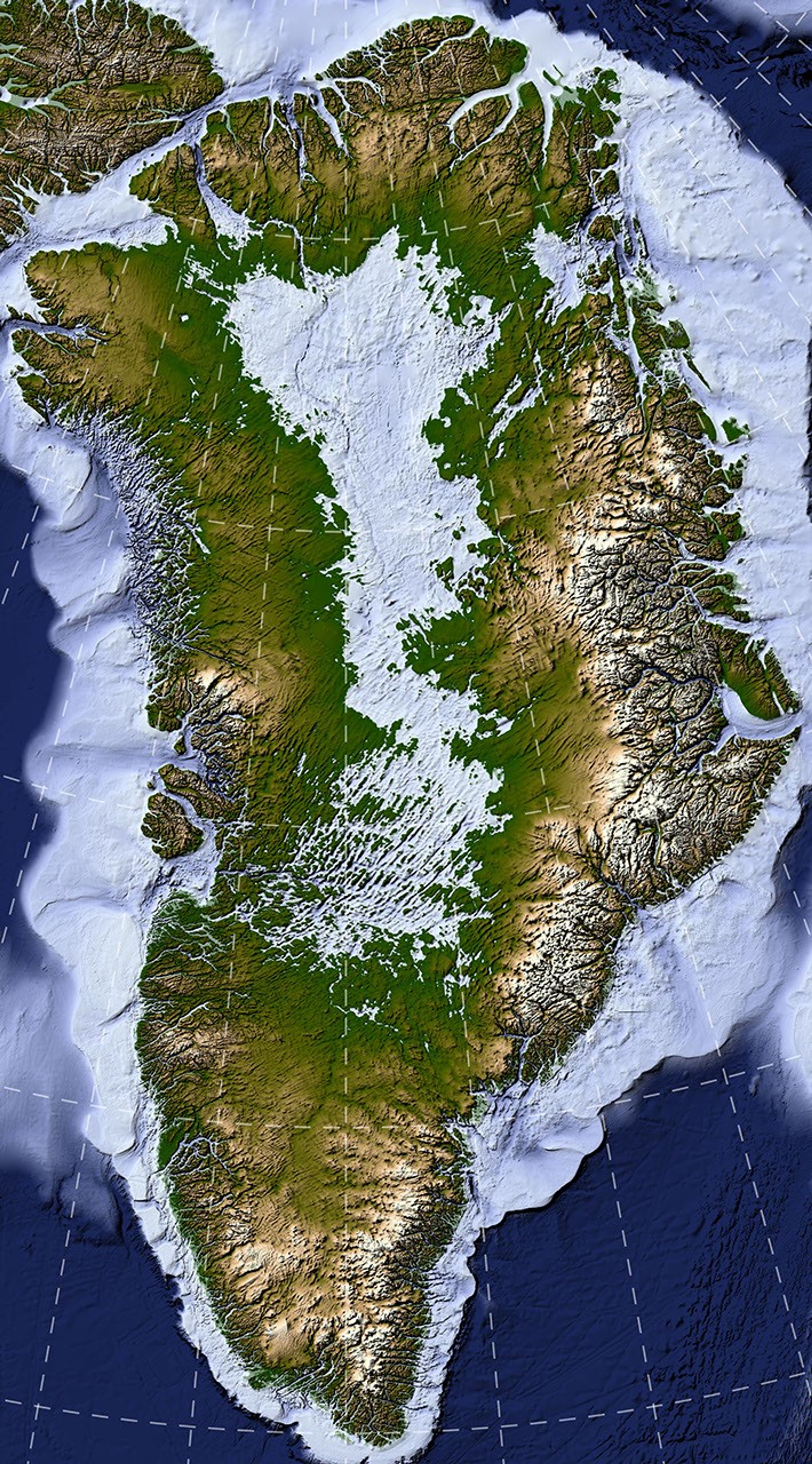
Beneath a massive ice sheet spanning 1.7 million square kilometers (656,000 square miles) and reaching thicknesses of over 3 kilometers (1.9 miles) lies a hidden world, unseen by human eyes for millennia. Now, a groundbreaking mapping technique has revealed the most detailed and accurate portrait of Greenland’s subglacial bedrock to date.
This newly unveiled topography showcases an extensive network of valleys deeply incised into the bedrock beneath the Greenland Ice Sheet. Many of these ancient features predate the ice sheet itself, offering unprecedented insights into the island’s geological history. By shedding light on these long-buried landscapes, the findings could also help scientists better predict the future behavior and stability of the ice sheet. The research, led by NASA scientists, was detailed in a paper published in Geophysical Research Letters.
The map was generated using a novel technique called Ice Flow Perturbation Analysis. As glacial ice flows over hidden valleys and ridges, the underlying topography leaves a subtle, faint signature on the surface. By mapping these micro-variations in the ice sheet’s surface with high-resolution satellite data, researchers can infer the detailed topography of the bedrock hidden far below. This breakthrough aims to significantly enhance BedMachine Greenland, a high-resolution dataset designed to model the terrain beneath the ice.
Applying this method, researchers identified and mapped 1,943 subglacial valleys beneath the ice sheet, with roughly one-third of these features representing entirely new discoveries. Furthermore, about half of the valleys previously cataloged near the ice sheet’s periphery are now known to extend much farther inland than previously thought—some by hundreds of kilometers.
Some features revealed by the map align well with existing theories of Greenland’s landscape evolution. For example, many of the valleys appear to originate in the southern and eastern highlands, regions where the ice sheet is believed to have first taken hold. Near the eastern highlands, the map uncovers a buried mountain range characterized by interconnected valleys and increasing coastal relief. These alpine-style landforms may have remained preserved under the ice since at least the Pliocene epoch.
Other aspects of the subglacial topography, however, present a scientific puzzle. The analysis highlights numerous long, straight valleys in the west-central region, consistently aligned along a southwest-northeast axis. This striking alignment suggests a tectonic influence, creating preferential pathways for water flow and valley formation. “That’s a riddle to us,” said Joe MacGregor, a NASA cryospheric scientist and co-author of the study. “Greenland is typically treated as a rigid block of ancient rock, simply translating to accommodate the motion of surrounding tectonic plates, yet these valleys suggest a more complex tectonic history.”
Additionally, the branching patterns of these valleys provide clues to their origins. Their relatively wide branching angles suggest that surface water alone could not have carved them. Instead, a widespread groundwater network, which seeped upward and eroded the surrounding rock from within, likely played a major role in carving these valleys before the ice sheet formed.
Understanding these buried valleys is crucial for comprehending how the ice sheet shapes and is shaped by the landscape. Ice flow naturally concentrates within valleys, forming glaciers that ultimately calve into fjords at the ice sheet’s margin. This dynamic establishes a reinforcing feedback loop: ice funneling through a valley accumulates thickness, thicker ice flows more rapidly, and this accelerated flow carves the valley even deeper.
This profound erosive power is particularly striking along western Greenland. MacGregor compared the glacially incised landscape to Yosemite, noting that Greenland’s western coast resembles, in his words, “El Capitan after El Capitan.”
Moreover, mapping these valleys is vital for predicting the future of the ice sheet. Because the relationship between ice flow and valley topography is well understood, scientists anticipate that as the ice sheet retreats, ice flow will continue to concentrate along these pre-existing valleys. “The better we understand the topography now, the better sense we’ll have of what it will look like in the longer term—beyond the next decade or two—as faster ice flow propagates into Greenland’s interior,” MacGregor explained.
NASA Earth Observatory map by Lauren Dauphin using data from Chartrand et al. Story by Kathryn Hansen.